Chapel Carn Brea, Cornwall
The last (or first) hill in England is a modest 198 metres above sea level. Hillock more than hill, Chapel Carn Brea is certainly no Munro: it’s a final unpromising, bracken-brown bump in the Cornish landscape, before a sheer drop into the sea at Land’s End. Not all walks need guidebooks and Nordic poles; some are coy, cloaking their secrets in the hope that power walkers will power on by.
I stroll straight to the summit (perhaps too grand a term) in less than 10 minutes. If I’d taken the circular path, close-cropped by the ponies for whom the hill is home, I could have stretched the walk to 20.
The medieval hermitage that gave Chapel Carn Brea its name is long gone, but numerous bronze age burial mounds still crown its top. On a clear, bright day, an arc of startling blue sea wraps around the hill, with views out to the Isles of Scilly, though nothing is visible when I’m there. All is lost to the deep Cornish dark, for it is night and I am seeking an alternative view.
I lie on the ground, looking up at a universe of starlight that is almost beyond belief. Designated an international dark sky park in 2021, the West Penwith peninsula has always been known for its exceptional light. Now it’s also known for its exceptional dark. I could see the same constellations from the car park, of course, but, somehow, up the hill, almost 200 metres closer to the stars, the experience is unparalleled.
Distance loses all rational meaning in the immensity before me. I spot Rho Cassiopeiae with the help of a night-sky app on my phone. This dim, unpromising star is apparently thousands of times brighter than our sun, but its light has taken 3,400 years to travel about 20 quadrillion miles, to reach me tonight on this hill.
When those beams of starlight left Rho Cassiopeiae four millennia ago, people were burying their precious dead on the summit of this unpromising little hill, and no doubt, they too, looked up. I leave reminded that I’m a speck, on a hillock, on a planet hurtling through space.
Bring a rug and a torch.
Christopher Morris, director of documentary film A Year in a Field, now on streaming services
Bannau Brycheiniog, mid‑Wales
On the morning of the opening performance of The Nutcracker, my daughter Alice was a ball of terror. Her part in the local production was tiny, but this would be her first public performance and nothing, it seemed, would comfort her.
In the end, we went for a walk, setting out into a mist so thick that the hedges reared as shadows and our dog, Wyn, disappeared at once. Drops shone dully on our hats and jumpers. Our wellies flopped against our legs. Holding hands, we climbed the lane and came on to the open common: barren contours, a few wan sheep fleeing off into the murk, a rowan fallen the previous December, which provided Wyn with a stick.
None of this was very uplifting.
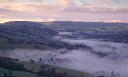
Then, perhaps half an hour from home, Alice and I emerged from the mist so abruptly that it might have been water. The sky became an unconditional blue. We live in Bannau Brycheiniog (formerly called the Brecon Beacons) in mid-Wales, and here on the flank of Twyn y Gaer we could see the full 30 miles from Hay Bluff on the English border to Fan Brycheiniog on the brim of Carmarthenshire: shadowed islands in a sea of light.
Just to the south was Pen y Fan, the highest peak in southern Britain, tapering to the huge white sun.
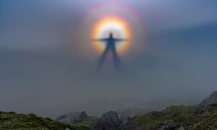
But this was not the revelation. Scrambling over the iron age earthworks, we arrived on the hilltop – and there were our shadows, cast on the mist across the Usk valley. The two of us were standing together, and around our shapes was a halo of colours – violet fanning to a brilliant red. Alice gawped. I gawped. It took some moments before I found the words “Brocken spectre” (the term for what can happen when a walker gazes down into mist, with a low sun behind them. Their shadow extends forward through the mist, surrounded by the shimmering rings of colour).
For an hour at least we played on the ridge, performing star jumps, chasing Wyn, and watching our projected selves – always in that rainbow ring, as if the soul or animating spirit were suddenly revealed.
With no one else in the whole, giant landscape, it was like a private display of hope. The ballet went absolutely fine.
Tom Bullough, author of Sarn Helen: A Journey Through Wales, Past, Present and Future
The Top of the Hill, Derry
We begin beside the river, where the “lightpeople” live, according to my toddler – at Londonderry-Derry’s Ebrington Square – where these days we find light in place of soldiers. This old army barracks is now used for celebration, the rituals with which our ancestors navigated the year’s circle now offered to us once more.
At Samhain, the Celtic festival marking the end of the old year and the birth of the new, performance group Luxe created a mythical, beautiful world here, of lights and fire and dance. As you walk through the square, see if you can imagine Babel towers and dancing creatures, warmth and shadows, for if we really listen to our elders, and place trust in their stories, place holds memory. Land is a palimpsest. We lay, over the top of what came before, all that happens today.
Onwards, along Clooney Terrace, lit now for winter, past the place where flowers are laid around this time each year – to remember one of many lives stolen by the violence that lived here once but is allowed here no longer. Up, up, climbing towards the Top of the Hill, tracing tiny, terraced streets, wains laughing, then crying, until we reach Annie’s Bar.
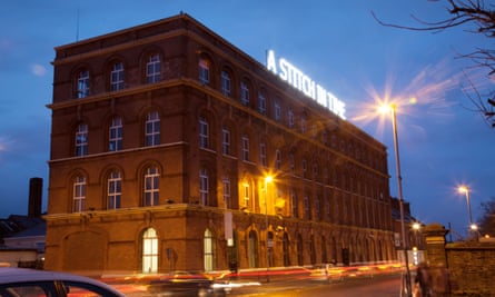
More flowers, this time to mark a shooting half a century ago – different group, same violence – gone long enough now for it to know it’s no longer welcome. Up another scoot to get a proper juke down and would ye look how far we have come. Sure, that is only gorgeous. There, right below you, is a city dreaming. A city full to the brim with bars (both kinds), craic (one kind) and pure kindness (multiple kinds). Look wile hard and you’ll see the old shirt factory, its lit-up sign: A STITCH IN TIME, and below it, Free Derry Wall.
Or maybe just take my word for it. You see sometimes blind trust is all we need. Other times, though, we must work at things. If ever there was a time to look towards this city of freedom and hard-fought, lasting peace – it is now.
Kerri ní Dochartaigh, author of the memoir Thin Places. Her latest book is Cacophony of Bone
Barrow upon Humber, Lincolnshire
Finding the way is easy at Barrow upon Humber. The north Lincolnshire village has a statue of John Harrison (1693-1776), the local clockmaker who finally solved the problem of longitude, making navigation easier and saving countless lives. It’s two miles from here along Ferry Road to Barrow Haven, a reedy creek reeking of mud and resounding with redshank. Henry VIII landed here in 1541, and there is still a tiny port, imported wood awaiting its fate beneath rusting cranes.
Little-used small boats list on greasy gunge where peewits probe for worms, as everything opens on to the Humber – which Michael Drayton’s epic 1612 poem Poly-Olbion calls, “King of all the Floods, that North of Trent doe flow”.
There are peregrinating possibilities in either direction: footpaths go east to Grimsby, or west to join long-distance paths to Rutland. Today, I will walk 12 miles, starting and finishing at Harrison’s feet.
This low-lying littoral was a frontier of the long-lost Kingdom of
Lindsey, then between Northumbria and Mercia. In 669, Saint Chad is said to have founded a monastery here, but war and neglect washed over it even before the Vikings invaded. New Northmen arrived after 1066, building a powerful motte and bailey to watch the estuary – now long‑shadowed lumps imprinted by sheep that look up as you pass.
Dun-green ivied thorns, crimsoned with rosehips, part-hide, glittering
the claypits that gave this area its red-brick vernacular – mostly ceded now to coot and cormorant and zigzagging snipe. Sun gilds the cotton-tips of reeds, and ice-stricken grasses blanket the embankment, along which solitary walkers are seen from afar, significant in such space.
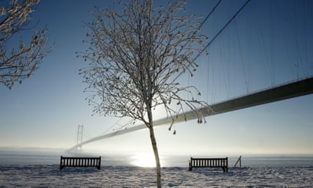
Unmissable under an endless sky is the Humber Bridge, graceful as the anchor-line of some stupendous spider. Walking across to East Yorkshire from Saxon-churched Barton, you feel its juggernaut-sustaining strength, and between rattling-rumbling lorries hear humming in high wires.
Below, sandpipers stretch shadows across striated slime, and the channel is coffee-coloured with unsettling silt. A coasting ship like an Airfix kit beats gallantly Goole-wards between Humbrol-hued buoys. Somewhere in the shimmering west, the Trent, Ouse and other rivers bleed ichor of England into the never-ceasing flow. On the return leg to Barrow, the sea can be seen or sensed out east, and something like infinity.
Derek Turner, author of Edge of England
Brimsdown Hill, Wiltshire
You never regret a cold swim, they say, but you also never regret a blustery midwinter walk, especially if there is a steep hill involved. The rewards of such endeavours – rosy cheeks and a rush of endorphins – are even more attractive with the promise of a good view and a moment to reflect.
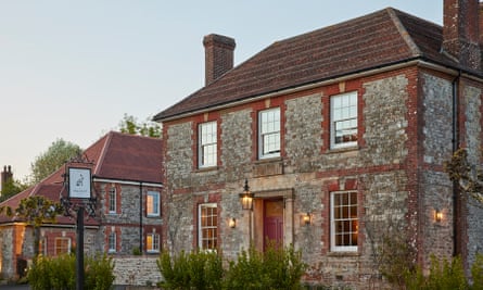
The fairly challenging climb of Brimsdown Hill, just outside the small village of Maiden Bradley in Wiltshire, promises such rewards and even has the allure of a new gastro pub, The Bradley Hare – a cosy place to thaw by the fire to look forward to on your return. The car park around the back is the perfect place to ditch the motor for a full-circle walk along hedge-lined lanes, across green fields and up to the Brimsdown.
The climb starts at the foot of the old medieval droveway (marked with a small fingerpost) off the road out of the village towards Kingston Deverill. The track runs along a wide-open field, following the route carved by the sheep and cattle that for centuries headed up to the chalk downlands to graze.
At the top, you emerge on to a steep windy ridge, passing an old tumulus, or bronze age burial mound on the left, before arriving at a clump of tall ancient beeches that appear to command the valleys below and conceal an even older Roman fort. The thought of ancient civilisations hidden beneath the frosty ground serves as a gentle reminder of our own mortality as the new year rolls in.
Here, beneath the shelter of the trees, is a perfect nest in which to recharge, reflect, and watch the clouds roll over the patchwork of fields and farms stretching north towards Longleat, south towards Cranborne Chase and west towards Alfred’s Tower, built to commemorate the defeat of the Danes by King Alfred.
Retrace your steps along the ridge and back towards the village to reward yourself with a local ale by the roaring fire, and feel reinvigorated for the year to come.
Sophia Seymour
Alderley Edge, Cheshire
A teacher at my north Cheshire school told us that the strangeness of Alan Garner’s books The Weirdstone of Brisingamen and The Moon of Gomrath was down to their setting: Alderley Edge, an ancient site of magic and mists and mysteries.
after newsletter promotion
Later – like a metaphor for modern Britain – the name Alderly Edge came to be associated with millionaire Manc footballers and their McMansions. Fable and folklore had been turned alchemically to dross. The large village of Alderley Edge has become eminently bypassable.
But the Edge itself, a lofty sandstone escarpment, retains something of my imagined landscape. It is walking distance from Alderley Edge station (1½ miles) or there’s a car park off the B5087, or Macclesfield Road, which runs along the borders of the National Trust-managed area. There are several paths in, but, whichever you choose, fields soon give way to woodland.
Alderley Edge is a surviving patch of the oak forest that once covered Cheshire and many other counties. It has plenty of oaks – including some veterans – as well as birch, rowan, holly, plus Scots pine and beech that are a hangover from 19th-century forestry exploitation. Paths crisscross the wooded areas, and it pays to take random turns and go slowly: the light inside varies with the weather and seasons, but it is always calming beneath the canopy.
For company, there are redstarts, nuthatches, tree creepers, woodpeckers and – apparently – ravens, though I have yet to see one. There are also bats. Fallen trunks and exposed rock and roots host a huge range of liverworts, hornworts and mosses, which enhance the enchanted-wood quality.
The Edge, a site of special scientific interest, is the only place in Britain where non-ferrous ores and the full range of sedimentary rocks are accessible for study. In short, it’s a fantasia for geologists as well as for naturalists and tree-lovers.
All of which would be sufficient reason to go. But the Edge gets its edge from its edge. Follow the light, or the fresh breezes, or whatever wizardy force comes upon you, and eventually you will come to Castle Rock, or Stormy Point, or just a clearing and a cliff edge, and there lies below and all around the Cheshire plain, the northern Peak District, the hazy central Pennines, and, in the top corner, the distant sprawl of Manchester and Stockport.
The view is like a luminous reward after a tramp through the dank and dark woods – especially in winter.
For more about Alderley Edge’s myths and history see nationaltrust.org.uk
Chris Moss
The Ragleth, Shropshire
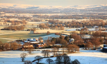
By the time we scale the Ragleth, the light is bright but low. Even the smallest trees have elongated doubles, every field brushed with long shadows. We arrived later than planned, a crash on the M1 having turned a three-ish-hour drive into a five-hour crawl via Milton Keynes’s finest roundabouts. Still, there’s nothing like stop-start traffic to make a steep, thigh-burning climb appealing. The calm of the lower slopes quickly gives way to scouring wind.
The Ragleth sits on one side of Church Stretton, a town girdled by hills. Most of those who arrive here in search of elevation head for the Long Mynd, a popular seven-mile plateau of heath and moorland where ponies roam wild and streams carve up the slopes. The Ragleth, standing opposite, is sparser. There is nothing on the ridge but bracken and a flagpole with no flag. Its austerity is its appeal, a single path leading along the hunched green line of its spine.
There are various ways up. Many walk from the train station, winding through houses to reach a wooded footpath. But we drive around the back, accessing the hill in a sharp 10-minute scramble, footholds cut into the ground to aid ascent.
At the top, the town sprawls beneath us: squat buildings, church towers, railway tracks, the white Long Mynd hotel with its red lettering like a miniature Hollywood sign for hikers. Smoke drifts from a farm. A rainbow curves over the Caradoc and disappears.
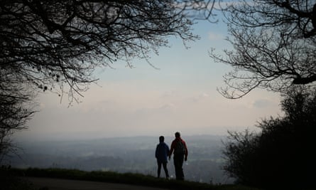
I grew up nearby, in a village a few valleys over. I don’t miss much about my home county, but I get itchy when I go without its views for too long. It’s the way they unfurl from any high point, all higgledy fields and far-reaching plains. I love the elating feeling of being so small in such a big landscape.
At the top of the Ragleth it’s easy to imagine being blown away: our coats and hair billowing, skin stinging. From down in the town, we are little more than crawling dots. Up here we are all-seeing, granted a 360-degree panorama of green. It is a plunge of a walk – quick, cold, enlivening. We make it to the flagpole and return with numb fingers. The sun squats low on the horizon. As we drive away my mother points out the bungalow she lived in for a year as a teenager, the windows already lit.
Rosalind Jana
Ben Wyvis, the Highlands
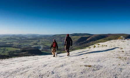
Ben Wyvis, a bulky, double-headed Munro, was the dominant presence in the landscape where I grew up. It heaves itself bodily from the soft, rolling agricultural land around, like a great beast baring the flat of its back. It makes a satisfying and easily achievable day walk – perfect if you’re looking to stay at altitude for a while so as to better appreciate the mossy upland habitats, the icy conditions on the tops, and, of course, the views across the Highlands, from the rugged peaks of Wester Ross in the north-west to the Cairngorms massif to the south.
To climb it, leave your vehicle in the car park just outside Garve. From there you’ll head roughly east, first on forest paths by the banks of the Allt a’ Bhealaich Mhòir, before bearing north-east on a rough track up the spine of 946-metre An Cabar, the first of two peaks, by which point you’ll have gained most of your altitude.
There are gorgeous views to the west here, down into a great bowl-like corrie, and to a glittering serpentine stream cutting through the steep glen to the south. The traverse from here to the (only slightly higher) second summit, Glas Leathad Mòr (1,046 metres), is satisfyingly easy, with the worst of your efforts behind you – although you must be prepared for high winds.
In fact, be prepared for anything. If you’re not a regular Munro-bagger, you may be surprised by how much difference a few hundred metres of height makes; in winter, the upper ridge is invariably in a climate of its own. I’ve left Garve in weak morning sunlight for a relaxed saunter up the hill only to navigate back down blindly in white-out conditions. So make sure to consult accurate weather forecasts, bring layers and an OS map, and tell someone where you’re going.
But I wish you clear skies and wide-open views. Ben Wyvis offers great rewards for relatively little effort. While you’re up on the plateau, look out for snow bunting and the fluffy-footed ptarmigan – two birds you are very unlikely to spot in lower lands.
Cal Flyn, author of Islands of Abandonment
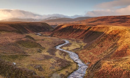
Wharram Percy, Yorkshire Wolds
Despite there being many ancient tracks, it’s hard to plot a satisfying circular route in the Yorkshire Wolds that doesn’t involve some road walking, although you’ll probably encounter more cyclists than cars. A circuit from the car park for the abandoned medieval village of Wharram Percy gives a flavour of the history, geology, archaeology, folklore and nature this fascinating chalk landscape offers.
On the access land of Fairy Dale (there are gates at the head and foot of the dale), you can climb to the small outcrop called the Fairy Stones, where local lore has it that by a full moon your true love will be revealed. Further down the dale is the entrance to the obsolete Burdale railway tunnel, and a gin-clear, spring-fed pond to tempt cold-water dipping enthusiasts. Exit at Burdale, from where a short westward diversion on the road will bring you to the giants depicted in David Hockney’s Three Trees Near Thixendale series.
From here, take the longer road route to Thixendale (a visit to the Robert Fuller wildlife art gallery at Fotherdale is worth the extra miles), or a short cut north to Deep Dale, where red kites soar and throngs of migrant thrushes (redwings, fieldfares, blackbirds) gorge on abundant hips and haws. At Wharram Percy, the ruined church and “improvement farm” that doubled as HQ for archaeological excavations are obvious, but you need to climb a grassy bank to see the outlines of the lost village, whose residents once practised the macabre dismemberment of their dead – perhaps to prevent an unwelcome return to life. Beyond a gate in the north-eastern corner a spring gushing out among hawthorns is a good place to refill water bottles.
Pick up the former rail route to old Wharram Station, then head uphill past Wharram Quarry nature reserve. You can then link back to the car park, or take a final detour to the source of England’s most mysterious stream. The Gypsey Race is a fickle flow around which an astonishing concentration of prehistoric monuments is clustered. There’s a reasonable chance you’ll find it running from a cluster of willows on a field boundary about 150 metres from the Wharram to Duggleby road, but never any guarantee.
Amy-Jane Beer, author of The Flow: Rivers, Water and Wildness, which won the 2023 Wainwright prize for nature writing
Box Hill, Surrey
The first mile is always the worst: the slowest, the moaniest, the one where the four-year-old asks for a carry and the seven-year-old says he’s hungry (already). Walking by stealth is the easiest way to get little legs going, and, for that, Box Hill’s natural play trail is a great trick to play: log forts to conquer, dens to build, zigzagging balancing beams to wobble along.
But that’s the prize – eyes on the prize kids. So, instead, we pull another sleight of hand and start by going downhill. The Stepping Stones walk is a topsy-turvy trail whose opening credits are the wide weald views from the Salomons Memorial at the top, the opaline blue sky streaked with wisps of white above the Surrey countryside as it rolls all the way into the South Downs.
This is our shortcut out of the city at any time of the year – a place to unfold from the concertina of a London terrace house – but there’s something especially lovely about Box Hill in winter. The ground crunches beneath your boots and the low sun flashes morse code between trunks as we tramp through the woods. There’s a quietness, a pause.
“One, two, three, four,” my daughter loves to count. It’s 275 steps down through the yew trees to the River Mole, where the 17 chunky stepping stones poke like a giant’s gappy teeth through the fast-flowing water. On the opposite bank we gather handfuls of twigs to play Poohsticks on the old wooden bridge just downstream. Breath rises like steam as they cheer the winner.
By the time we go through the kissing gate to Burford Meadow, they have hit their stride and are whirling and bounding ahead through the crisp grass like dogs. No one needs to be bribed to make the final push, the steep grassy slope turning to white chalk as we race each other up the ridge to the top. There, everyone throws themselves on the ground and watches a bird hang, seemingly still, on the current above.
Box Hill is named for the ancient box woodland that grows on these slopes, trees that are more often clipped and domesticated as hedges in front gardens. But here on the hillside, the evergreen branches are thick and tangled around us. A reminder of the beauty of being left to go a little bit wild.
Fiona Kerr